What you need to know about oceanography In The USVI
70% of the Earth’s surface is covered by oceans and, as the US Virgin Islands are mere specks in the northeastern Caribbean, we are directly impacted by its influence. Oceanography is the study of the Earth’s oceans and is central to understanding the mysteries of its vast yet largely uncharted depths.
Only 5 percent of the oceans have been explored but we already know that their impact upon the earth is significant. On a global scale, oceanic processes like the continuous exchanges of heat, moisture, and carbon with the atmosphere influence the earth’s temperature and weather. Most rainfall is tied to these processes and, as the USVI is in the midst of a long-term drought, we know that a number of these oceanic dynamics are exacerbating the drought.
On a local scale, ocean currents and water temperatures have a direct effect upon biological processes such as coral recruitment, coral bleaching and fish spawning. Currents also influence the dispersal of marine animals in their egg or larval stages, as well as the dispersal of their food supply and nutrients. These same currents can help determine where larvae, eggs and even coral polyps will settle and grow. Life in the sea is inextricably linked to these ocean processes.
Oceanic Data Supports Coral Research
One of the functions of the Ridge to Reef (R2R) Oceanography research area is to provide data to the Coral Reef Resilience Team.
Coral bleaching and thermal stress are ongoing concerns, and these events are completely dependent upon the ocean’s (and therefore, the earth’s) climate. One example of the partnership between these research areas is that by using data collected from oceanographic equipment and insights from ocean models, coral specialists can often predict where and when a coral bleaching event may occur. The ability to anticipate coral bleaching events allows researchers to closely study affected and less affected areas and identify which corals survive. These survivors may be more resistant to warmer sea temperatures. Surviving corals can be earmarked for coral restoration projects which aim to create a more robust collection of corals capable of surviving a warming planet.

Above, a lone Elkhorn coral survivor at Stumpy Bay, St. Thomas amongst an entire reef of dead Elkhorn colonies. Since this specimen has survived all previous bleaching, disease, hurricanes, and other disturbances, researchers are using fragments of this coral to propagate it and grow it onto other reefs. Photo: Dan Mele
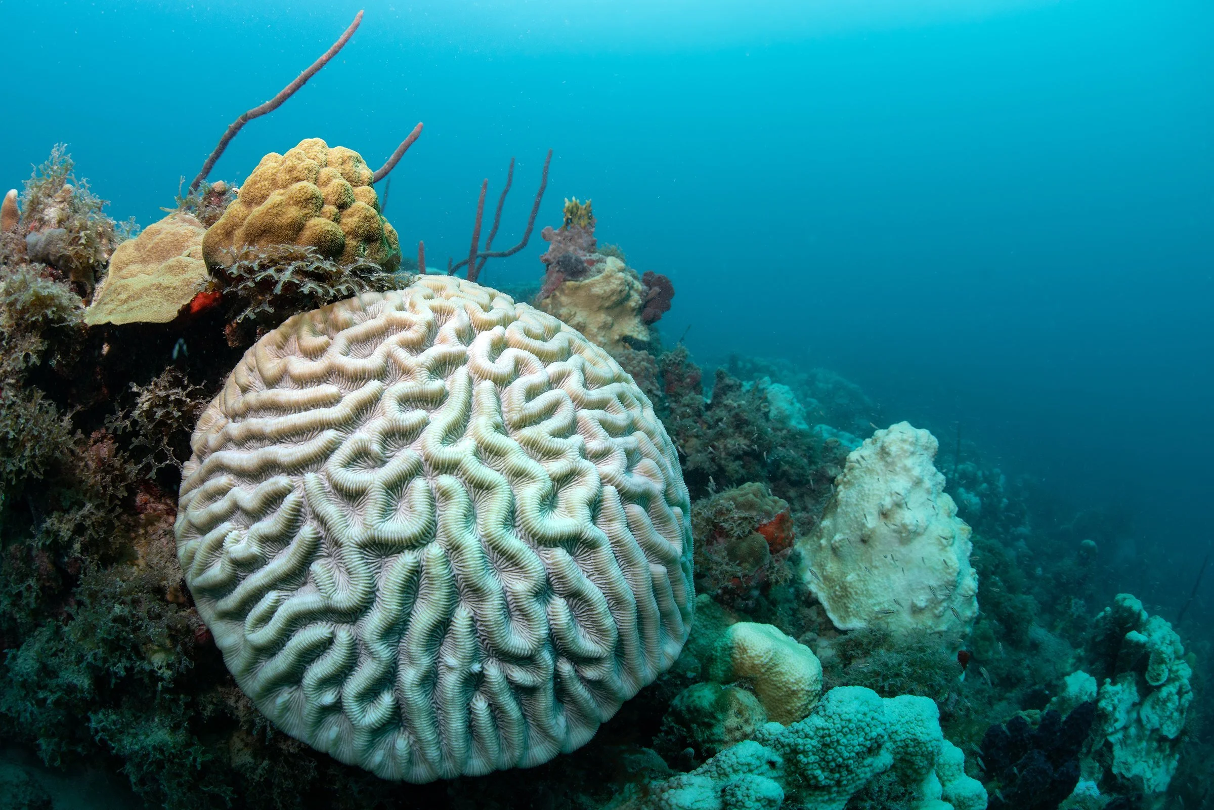
Above, this Boulder Brain Coral in Brewers Bay, St. Thomas was badly affected during the 2019 mass bleaching event. Hot ocean temperatures can greatly stress a coral and sometimes but not always lead to death by starvation. photo credit Dan Mele
Fish Ecologists Use Oceanographic Equipment for Richer Data Sets
The R2R Fish Ecology research area also relies on oceanographic data and the team is currently using Nortek Acoustic Doppler current profilers (ADCP) at their yellowtail parrotfish study sites in Reef Bay and Europa Bay, St. John. The team aims to learn which oceanographic variables are most impactful to parrotfish spawning frequency and reproductive output. Data on variations in current speed and direction, seawater temperature, wave height, salinity and turbidity are all being collected by the ADCPs. The profilers also contain echo sounders that record the density of eggs released by parrotfish at their spawning sites. The data collected will help the team develop a better, more rounded understanding of the parrotfish's feeding and spawning behavior and will be integrated into connectivity models for the region.

Above, Postdoc Kayla Blincow-Israel is seen recording the depth of an ADCP deployed at one of the parrotfish study sites. Photo: Rick Nemeth
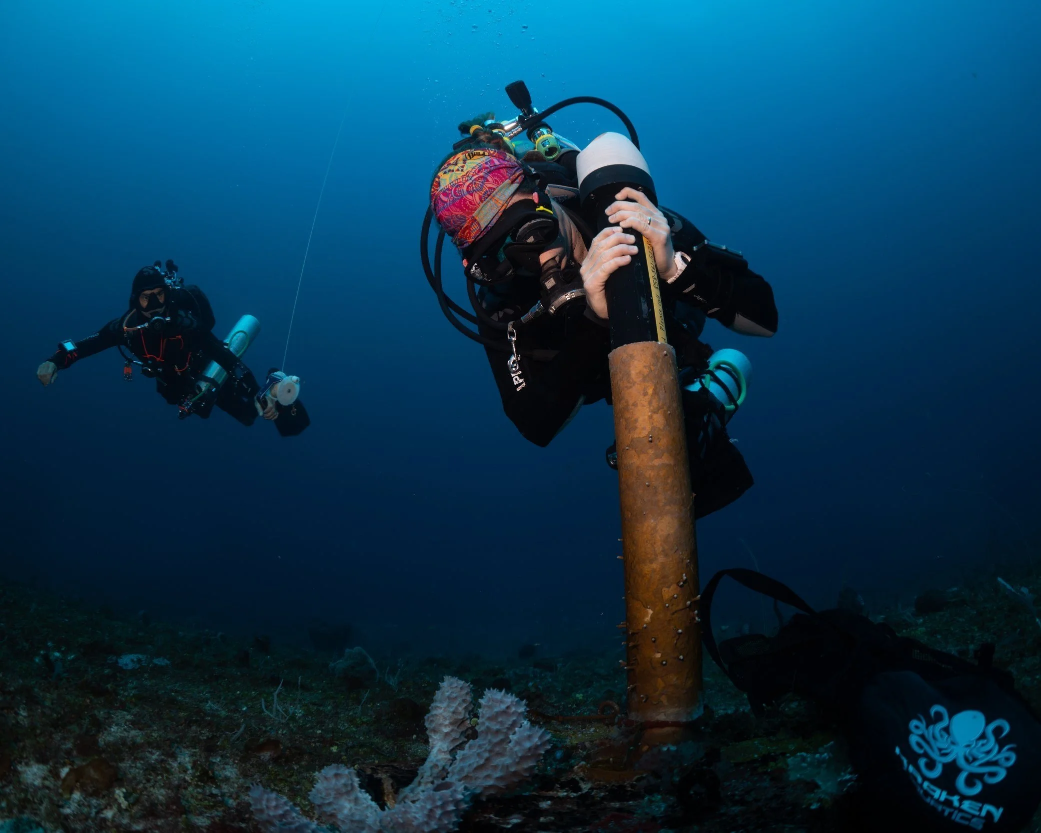
Sarah Heidmann, Coral Reef Research Coordinator at the University of the Virgin Islands (UVI), assisted by Jason Quetel, Marine Life Restoration Specialist, UVI, swap out an ADCP at the Grammanik Bank south of St. Thomas. It is placed at a depth of 150’, right at the edge of a slope that drops off to over a few thousand feet deep. These ADCPs will measure current speed from the ocean floor all the way to the surface using sound waves at a frequency beyond what humans and animals like dolphins can hear. Photo: Dan Mele
Oceanographic Equipment Are Very Technical And, Very Cool
It may seem that oceanography is relevant only to marine scientists and fishermen, but how is it applicable to the terrestrial world? Well, as mentioned previously, the ocean controls our local weather and influences dynamics like the drought we are currently experiencing. Hurricanes too are directly linked to ocean temperatures. For example, much of the intensification of the two Cat5 hurricanes that impacted the territory in 2017 was likely because we had very warm ocean waters on the surface but also at depth surrounding our islands at that time. These overly warm waters became a huge energy source that fed the storms resulting in very rapid cyclone intensification. The ensuing damage was catastrophic.
One of the new and exciting advances in oceanographic monitoring equipment is taking place in the arena of ocean glider technology. Ocean gliders are a type of autonomous underwater vehicle. These unmanned remote-controlled ocean gliders provide real-time data on ocean temperatures, salinity, dissolved carbon and many other ocean properties across a depth range from the surface to 3,000 feet underwater. With respect to hurricanes, these gliders gather ocean data in the path of a hurricane and send that data back to shore through satellites. The data are helping scientists more accurately predict the strength and intensification of an approaching storm. Meteorologists predict a higher frequency of very strong storms and a higher frequency of storms in general. In fact, the last seven years were all above average hurricane seasons with 2020 being the most active hurricane season ever recorded. Instruments like ocean gliders can more accurately predict when and where the next hurricane will land so those living in its path can take measures to safeguard life and property.

Above, a Slocum glider returns to the surface after a dive. It was launched by Ocean and Coastal Observing Virgin Islands (OCOVI) as part of a project to better understand hurricane intensification. Photo: Dan Mele

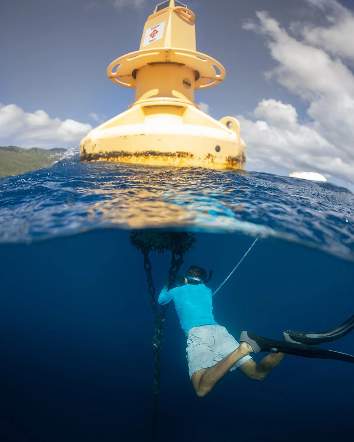
Another type of sensor used by Oceanographers are wave buoys. Wave buoys collect loads of data that proves to be valuable to researchers, fishermen and even surfers. In the photo above, these buoys were installed off the tip of the Cyril E. King Airport runway in St. Thomas where it measures the energy of the waves and currents flowing into Brewers Bay. This information is used to learn more about how that energy impacts the hawksbill and green sea turtles tagged in the bay as part of ongoing R2R Emerging Areas research. Photo: Dan Mele

Former UVI undergrad Kenique Liburd and Double Header captain Matt Driscoll prepare a glider for deployment. Both were born and raised in the USVI. Photo: Dan Mele
Above, MMES student Andrew McGregor is securing a wave buoy near Brewers Bay, St. Thomas. Photo: Dan Mele
Students are essential to the deployment, maintenance, and data interpretation of these devices. In fact, students in UVI’s Science 100 lab are introduced to oceanographic concepts early in their career with labs that include discussions on the dynamics of tsunamis and how ocean-atmosphere interactions may lead to hurricanes, among others. Naomi Scott, MMES oceanography advisee, brought her experience in this area to the classroom as the SCI 100 teaching assistant for two years. It was a great benefit to the students to learn firsthand more about the field of oceanography and the service-learning options available to them.
Similarly, the work of Jarvon Stout, our Community Engagement Specialist, in his partnership with the Upward Bound program at UVI, has introduced oceanography to USVI youths participating in the program. Ocean glider technology has been of great interest to the teens and, as we know, it often takes only a spark to light a fire.
The Team
The complexity of oceanographic data and the equipment used to collect it underscores why it is so important that career opportunities exist here in the USVI. The current VI-EPSCoR Ridge to Reef project, is building upon the four previous EPSCoR-funded projects which have created the infrastructure needed to support this research area.
Dr. Tyler Smith
The Oceanography team is led by Dr. Tyler Smith who also leads the Coral Reef Resilience area. Dr. Smith’s work in this area focuses on understanding how some coral reef communities can resist and recover from disturbances such as marine heat waves while others just can’t. Understanding of these dynamics helps scientists more strategically focus limited management resources. Photos: submitted by Dr. Smith.


Dr. Sonaljit Mukherjee
Dr. Mukherjee is the team’s physical oceanographer creating coastal ocean models of the region. Dr. Mukherjee’s publication (Mukherjee et al. 2022, https://doi.org/10.1080/1755876X.2022.2059885) of the United States Caribbean Regional Ocean Model (USCROMS) greatly improves on previous ocean models by providing a high-resolution model that is expanded to cover the entire US Caribbean and Puerto Rico. This model is being linked to the connectivity modeling system developed by Louisiana State University Louisiana EPSCoR (LSU/LA EPSCoR) collaborator, Daniel Holstein, to conduct a variety of research questions. Together these models significantly increase the regional research infrastructure and are the first of the numerical ocean modeling papers to be published by UVI.


Dr. Mukhergee explains his bathymetry model of the US Caribbean region. The colors represent ocean depth with purple being the deepest and yellow the shallowest. This information is used to set the dimensions for the models. Dr. Mukhergee can be contacted via email. Photos: Dan Mele
Vanessa McKague
McKague is the Oceanographic Technician for the team. When oceanographic equipment has been to sea for a while, it needs to be cleaned and calibrated and collected data needs to be uploaded to a server where it can be accessed by the team, students and partner scientists.


Right, McKague is holding the same ADCP retrieved at the Grammanik Bank by Sarah Heidmann as seen in a previous photo. We can see it is covered in algae. McKague will clean it and download the data before preparing it for its next deployment. Photos: Dan Mele

Travis Hamlin
And of course, what do we do with all the data collected? It’s uploaded to a secure cloud server managed by Hamlin, our Data Manager and Oceanographic Data Technician. The data may be accessed by UVI scientists to support and inform their research. File photo.
It is with a real sense of partnership and commitment to shared goals that the research arms of the Ridge to Reef project support and balance each other. The Oceanographic team is essential to understanding how our marine ecosystem functions and how marine life might respond to increasing temperatures and other environmental stressors made worse by the impacts of climate change.
Written by Elisa Bryan and Dan Mele